Day 1 – To El Time panorama and the Barranco de las Angustias
This was our first experience of coach travel on La Palma – nowhere is on the level on this island and roads compete to climb or descend with the maximum number of hair pin bends. Fortunately we were soon favourably impressed by the coach’s comfort and reliability, the skills of the drivers and the quality of most roads, including recent improvements like tunnels.
From our base on the east coast, just south of the capital Santa Cruz, we headed up and generally westwards to the first [and longest] tunnel which bisects the central ridge of the island. We entered the tunnel in cloudy conditions and emerged into bright sunshine on the western side. This climatic split was a daily event whilst we were there and reflects the impact of the moist north east trade winds meeting the heights of the island. What was even more impressive was the brilliant cloud waterfall or cascade on the west of the ridge where the clouds are propelled downwards until they quickly disperse.
El Time
Our first stop was at El Time a café and viewpoint situated about 2000 feet above, but very close to, the western coastline. A panorama indeed and well chosen to get a feel of the island’s geology -- both visually and by way of introductory explanation from Geoffrey.
Geological history of the Canary Islands Archipelago
There is a 1000km arc running through from south of the Strait of Gibraltar to La Palma. Initially seamounts/guyots, through low islands which are in an erosional phase, then moving onto this island and El Hierro which are volcanically active. The latter had a 5.3R scale earthquake in December.
The oldest islands are 500km to the east with an average decrease in age as we move westward. Thus:
Oldest seamount Lars 68MY
Oldest Island Lanzarote 27MY
Fuerteventure 24MY
Gran Canaria 15MY
Tenerife 12MY
La Gomera 9MY
La Palma 4MY
Youngest El Hierro 1.7MY
Geoffrey reiterated the controversy about the cause of this trend ie is it a mantle plume creating a hot spot in the form of intra plate vulcanism as a tectonic plate moves across the earth’s surface eastwards away from the mid Atlantic ridge? The same trend is seen in the Madeiran Archipelago too.
Geological History of La Palma
About 4 MYA a seamount formed with lots of submarine eruptions. It reached the surface about 2MYA.
Initial sea floor bulging led to formation of fissures which in turn triggered first submarine and later subaerial eruptions and the formation of Volcan Garafia about 1.5 MYA. The only evidence left of this in galerias (water tunnels) and in the deeper northern Barrancos (valleys).
A period of relative dormancy followed before other smaller eruptions. Next came the major eruption that formed Volcan Taburiente which grew to a height of between 2500 and 3000m
Finally a fresh volcano erupted continuing the southerly trend that still continues and is known as Cumbre Nueva
Looking out from our viewpoint we could pick out the caldera remains of Taburiente and the developments southwards of Cumbre Nueva and Cumbre Vieja. But what had caused the caldera and the massive slash of the Barranco de Las Angustias across the landscape in front of us and on to the sea? We recognized too that the east of the island is steep with deeply incised valleys whilst in front of us south of Las Angustias, the land is concave, more gentle and not deeply incised.
About ½ MYA there was a very steep, complex and conical volcano. It was unstable with poorly consolidated rock and with major unconformities. It was also very porous and the water in the rock pores was heated internally by magmatic heat caused by the injection of dykes. This water expanded and possibly flashed into steam (1cu m of water forms 1300 cu m of steam). So a considerable internal outwards acting force built up only requiring an earthquake to trigger a massive material movement south westerly down to the ocean. The scale was phenomenal – maybe 100 cu km or 3,000,000,000,000 tonnes. And this was the third time it had happened here with the total for all slides adding up to 750 cu km or 13% of the present volume of the island. Some of the blocks involved were 1km across and 500m tall. The avalanche speed was probably up to 100 m/second. Tsunamis inevitably followed – though finding direct evidence of their consequences is difficult. Seabed debris reaches 60km from the shore.
It might happen again. Following the 1949 eruption some large surface fissures opened up high on the Cumbre Vieja. Perhaps another collapse may be triggered by an earthquake, but certainly not in the near future.
This type of gravitational collapse is common in the Canary Islands. The curved shape feature that results is known as an embayment.
Removing all that built up pressure also had a further dramatic effect. It triggered a new volcano – Volcan Bejenado. The erupted material blocked off the drainage system from the partly collapsed caldera.
In terms of recent geology we learnt that there had been glaciation in the highest parts of the island and that this in turn led to the formation of a lake within the caldera. At some point this broke through creating a further erosion impact. Evidence of sedimentary deposits from the lake exist in the lower part of the Barranco.
Landmarks
El Time is an excellent vantage point to spot the different volcanoes, the huge scar of the Barranco, other small cinder/spatter cones and the landward extension resulting from the 1949 eruption. We had earned our coffee!
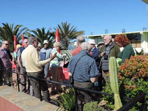
Geoff explaining the geology of the island at the El Time café.
Barranco de Las Angustias
Having talked theory it was now time for a hands on session within the Barranco. To access we had to retrace our steps down into the lower sections of this steep valley and up the opposite side to Los Llanos. Then the driver and coach proved their worth by taking a narrow and quite precipitous route back down into the Barranco to a position where the gorge entered the base of the caldera. After a picnic lunch we spent a couple of hours examining rocks and features within and adjacent to the almost dried up river. Aspects studied included:
Water formed sediments in the Barranco walls
Different basalts, gabbros, xenoliths and their chemical make up.
Sills and dykes within the cliffs on either side. Contact metamorphism.
Remains of a [probably submarine] land slide which had subsequently been cemented together.
Effects of chemical and physical erosion.
Impressive displays of pillow lava from the early days of submarine eruptions.
Shallow drilled holes in some rocks – where researchers had extracted cores to help date the rocks by analysing the magnetic fields locked in at the time of deposition.
One exposure we could not handle was the sedimentary lake deposits . These could only be admired and photographed through the coach windows [between one hairpin bend and the next!]
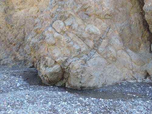
Some interesting pillow lavas and dykes at Barranco.
Conclusion
La Palma is a great place to pursue geology and we had another 5 days to make the most of it!